We use cookies to ensure our site functions properly and to store limited information about your usage. You may give or withdraw consent at any time. To find out more, read our privacy policy and cookie policy.
Manage Cookies
A cookie is information stored on your computer by a website you visit. Cookies often store your settings for a website, such as your preferred language or location. This allows the site to present you with information customized to fit your needs. As per the GDPR law, companies need to get your explicit approval to collect your data. Some of these cookies are ‘strictly necessary’ to provide the basic functions of the website and can not be turned off, while others if present, have the option of being turned off. Learn more about our Privacy and Cookie policies. These can be managed also from our cookie policy page.
Strictly necessary cookies(always on):
Necessary for enabling core functionality. The website cannot function properly without these cookies. This cannot be turned off. e.g. Sign in, Language
Analytics cookies:
Analytical cookies help us to analyse user behaviour, mainly to see if the users are able to find and act on things that they are looking for. They allow us to recognise and count the number of visitors and to see how visitors move around our website when they are using it. Tools used: Google Analytics
Share Design Code - Area Types and Street Typologies on FacebookShare Design Code - Area Types and Street Typologies on X (formerly Twitter)Share Design Code - Area Types and Street Typologies on LinkedinEmail Design Code - Area Types and Street Typologies link
Area Types
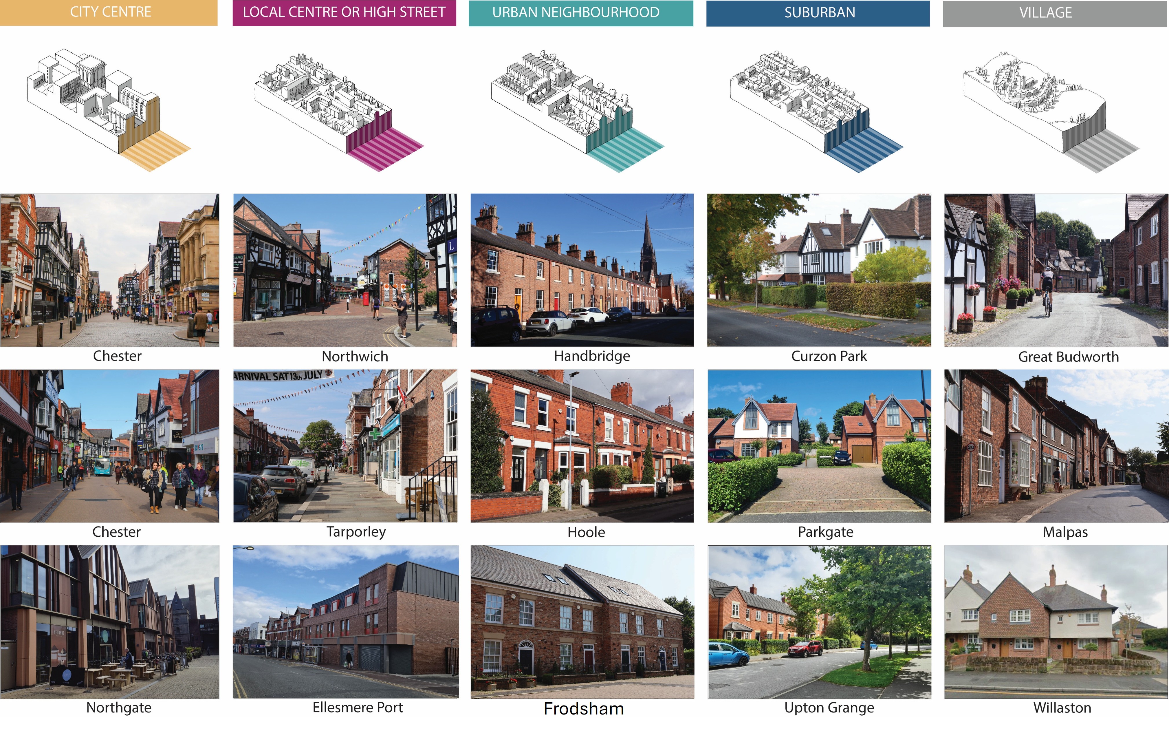
The rules within the Design Code are influenced by Area Types. The Area Types have been defined in line with the National Model Design Code that helps create places with varied character that people value. Most towns and villages contain a mix of Area Types, with compact, denser centres to quieter residential areas and greenspaces. Understanding these differences helps to ensure that new developments enhance the character of each place.
Development must respond to the settlement character and where residential schemes of 250 + dwellings are proposed they must provide at least 2 Area Types.
The five defined Area Types are:
Chester City Centre
Local Centre or High Street - for example the centres of Northwich, Tarporley and Ellesmere Port
Urban Neighbourhood - for example Ermine Road in Hoole, Handbridge and Trinity Gardens in Frodsham
Suburban - for example Curzon Park, George Drive in Parkgate and Upton Grange in Chester
Village - for example Church Street in Great Budworth, Church Street in Malpas and Neston Road in Willaston.
These are illustrated in the pictures below.
Street typologies
Street types help balance how streets are used for travel and as places where people live, meet and spend time. Creating a clear street hierarchy ensures that each street is designed appropriately for its purpose, location and intended use, resulting in places that are easy to navigate, well connected, safe and meet the needs of local communities.
This table provides a range of street types that can be used in new developments, helping to make the design and planning process more efficient.
Street type
Description
Principal streets
Larger streets that carry traffic through an area, while also providing space for buses, walking, wheeling and cycling in attractive, tree-lined neighbourhoods
Primary residential streets
Main streets that carry higher levels of traffic, including buses and other public transport
High streets
Busy streets with shops, services and places for people to move around, meet and spend time
Secondary residential streets
Streets that connect different neighbourhoods and may include schools, community facilities and local traffic
Tertiary streets
Narrow lanes, mews streets, access lanes or alleys that mainly provide access to a number of homes or buildings and frequently limit vehicle access
Industrial roads
Roads in industrial and business areas, connecting sites to main roads while providing safe access for people walking, wheeling, cycling and using public transport
Area Types
The rules within the Design Code are influenced by Area Types. The Area Types have been defined in line with the National Model Design Code that helps create places with varied character that people value. Most towns and villages contain a mix of Area Types, with compact, denser centres to quieter residential areas and greenspaces. Understanding these differences helps to ensure that new developments enhance the character of each place.
Development must respond to the settlement character and where residential schemes of 250 + dwellings are proposed they must provide at least 2 Area Types.
The five defined Area Types are:
Chester City Centre
Local Centre or High Street - for example the centres of Northwich, Tarporley and Ellesmere Port
Urban Neighbourhood - for example Ermine Road in Hoole, Handbridge and Trinity Gardens in Frodsham
Suburban - for example Curzon Park, George Drive in Parkgate and Upton Grange in Chester
Village - for example Church Street in Great Budworth, Church Street in Malpas and Neston Road in Willaston.
These are illustrated in the pictures below.
Street typologies
Street types help balance how streets are used for travel and as places where people live, meet and spend time. Creating a clear street hierarchy ensures that each street is designed appropriately for its purpose, location and intended use, resulting in places that are easy to navigate, well connected, safe and meet the needs of local communities.
This table provides a range of street types that can be used in new developments, helping to make the design and planning process more efficient.
Street type
Description
Principal streets
Larger streets that carry traffic through an area, while also providing space for buses, walking, wheeling and cycling in attractive, tree-lined neighbourhoods
Primary residential streets
Main streets that carry higher levels of traffic, including buses and other public transport
High streets
Busy streets with shops, services and places for people to move around, meet and spend time
Secondary residential streets
Streets that connect different neighbourhoods and may include schools, community facilities and local traffic
Tertiary streets
Narrow lanes, mews streets, access lanes or alleys that mainly provide access to a number of homes or buildings and frequently limit vehicle access
Industrial roads
Roads in industrial and business areas, connecting sites to main roads while providing safe access for people walking, wheeling, cycling and using public transport